Geonetwork
A Metadata (from the Greek meta “beyond, after” and from the Latin datum “information”) is the information that describes a digital resource. A Catalog is a discovery service powered by the metadata, which constitutes a real “catalog” of data and services managed by a Spatial Data Infrastructure (SDI). It allows users to search for information in OGC - CSW (Catalog Web Service) format. Once the data or service of interest has been identified, its metadata can be consulted and downloaded. Where required by the dissemination policies adopted by the owners, the user can download the data or request the access.
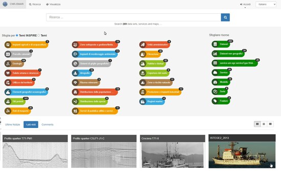
This Metadata Catalogue is implemented using the open source software GeoNetwork for the management of spatially referenced resources. It represents an organized collection point for spatial data produced by the CNR-ISMAR, but also services, maps or even non geographic datasets, with the aim to share and exchange information about.
- The presence of data in the geographical database;
- The access mode and use of geographic data;
- The usability of data in specific application contexts;
- The systems and procedures used for the production of data;
- The points of contact.
The Catalogue is part of a Spatial Data Infrastructure (SDI) developed over the years at the CNR-ISMAR based in Bologna, in the framework of various national and international research projects and for operational requests. The other components of the SDI are: a relational spatial database inspired by the data models proposed by the INSPIRE Directive; a WebGIS that integrates and makes accessible the digital resources described in the catalogue; and a cloud storage for data flow management.
Advantages
- Find & Get information: users can search geospatial data through an easy to use web interface. The search provides full-text search as well as faceted search on keywords, resource types, organizations, scale, etc. Users can easily refine the search and quickly get to the records of interest.
- Describe & Publish: Users can describe information using the online metadata editing tools. The metadata editor support ISO19115/119/110 standards used for spatial resources and also Dublin Core format usually used for opendata portals. Based on user profiles, a dashboard provides easy access to their informations and tasks. Online editing of metadata is based on a template system and directories of information (eg. contacts, thesaurus). The editor provides uploading of data, graphics, documents, pdf files and any other content type. It supports among others:
- multilingual metadata editing,
- validation system,
- quality check,
- geopublication of layers as in OGC services.
- Resources managment: the administration can manage user and group accounts, classification systems, and schedule metadata harvesting from many sources including:
- OGC-CSW 2.0.2 ISO Profile,
- OAI-PMH,
- Z39.50 protocols,
- Thredds,
- Webdav,
- Web Accessible Folders,
- ESRI GeoPortal,
- Other GeoNetwork node.
To get an account, please contact:


